Project History and Background
(1)Introduction of Project Origin
Land use types have become more and more complicated along with growth in economic development and social changes. For effectively preventing illegal or improper development, various domestic competent target business authorities, such as Construction and Planning Agency of Ministry of the Interior (CPAMI); Soil and Water Conservation Bureau, Council of Agriculture, Executive Yuan (SWCB); and Water Resources Agency of MOEA (WRA), have individually conducted land use monitoring within their jurisdiction using satellite images and remote sensing technology for more than 10 years.
Satellite images obtained from different periods of time can be compared to determine points of ground feature changes and suspected illegal uses. Such kinds of information should be sent to the local governments, and competent target business authorities. Personnel will be then dispatched to conduct onsite inspections, and follow-up handling processes to objectively and effectively implement land resource management. In response to different business needs in the past, CPAMI, SWCB, and WRA each executed land use monitoring within their jurisdictions by employing different monitoring frequencies, reporting approaches, and satellite images with different resolutions according individual needs. Thus, it hindered governmental resource sharing.
To facilitate the integration of government resources, the Council for Economic Planning and Development, Executive Yuan (now National Development Council, Executive Yuan; NDC) convened the “Overall Establishment Plan of National Land Information System-First Review Meeting of 2013 Preliminary Operation Plan” on April 19, 2012. It concluded to determine that the Ministry of the Interior should act as the competent authority to coordinate and integrate monitoring plans of relevant agencies to avoid repeated investments of national resources. The Ministry of the Interior convened meetings beginning from 2012, and had reached to the conclusion that the National Land Surveying and Mapping Center (NLSC), Ministry of Interior (MOI) should integrate the existing monitoring plans of CPAMI, SWCB, and WRA beginning in 2014, and anew establish an integrated reporting system to be completed yearly.
(2)History of promotion

The NLSC is in charge of monitoring the interdepartmental monitoring program of the Ministry of the Interior so that the program resources and achievements of CPAMI, SWCB, and WRA can be shared and applied smoothly in accordance with the past operational mechanisms. In other words, it must actively collect and understand the differences in the monitoring projects from different agencies to consolidate the requirements in planning resource integration, monitoring periods, value-added applications, easy notifications, and others. The priority of the integration is to standardize the frequencies of monitoring and the resolution specifications of satellite imagery used in the project.
The NLSC is mainly in charge of production, notification, and coordination related to change areas with suspected violations in various phases. CPAMI, SWCB, and WRA are responsible for audit, investigation, supervision, and appraisal operations with respect to reports of change areas with suspected violations provided by various execution units.

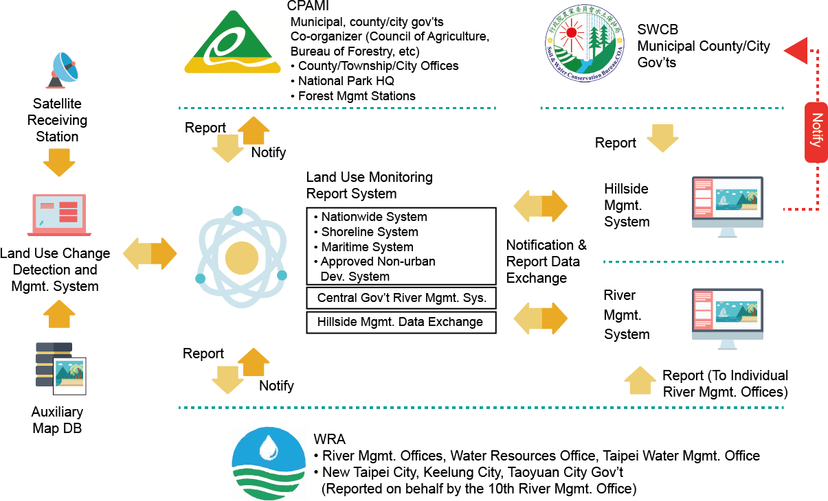
Summarily, the monitoring requirements of the three agencies, CPAMI, SWCB, and WRA, include land use monitoring, change detection monitoring and notification, value-added applications, and personnel training. The working items of this integration project are mainly to conduct consolidation of public bidding and establishment of an integration system that could be operated for all other agencies on one hand, also with no any interruption of original works on the other hand. The change detection areas are posted to the monitor notification system so the three agencies can inform coordinators in each government unit (including organizers, co-organizers, and executive units) about change area investigations and follow-ups.
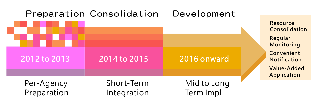
Inconsistencies existed among the original monitoring notification and report systems of CPAMI, SWCB, and WRA. To facilitate online reporting operations, the original monitoring reporting and inspection systems (including functions, change area reporting, and feedback procedures) of all agencies were analyzed in 2014 to complete the architecture of the integrated national land use monitoring notification and report system (hereinafter referred to as the integrated system). The overall planning for its operation mechanism, based on the newly developed integrated system, was completed in 2015. Beginning in 2016, all agencies can receive information of change area and feedback inspection results via the integrated system. It provides an effective platform for cross-agency change area transfer and information communication to reduce the time required for administration procedures and official document delivery. Agencies newly included in the monitoring integration can also directly use the integrated system to execute inspection and reporting without the need to develop individual reporting and inspection systems. Each land management agency can also receive change area information via the integrated system for business management needs. The integrated system was officially launched on December 3, 2015, for each coordinating unit to report suspected change areas of violations and inspection/reporting operations.

Originally, a medium and long-term plan set by the Ministry of the Interior scheduled to run the integrated system in 2016 . Actually, this integration preparation phase and the short-term project were performed fluently. The integrated system started the online service on December 3, 2015 earlier than schedule. The administrative measures planned to follow among organizations in the future and operational mechanisms have been readjusted well. It will continue to meet user feedbacks and adjust over time to ensure that the change detection and reporting systems work well. Moreover, in accordance with business requirements from all agencies, satellite imagery applications will be developed accordingly to fulfill land use management policy.
..
National Land-Use Monitoring
Satellite remote sensing imagery is equipped with characteristics of short data acquisition period, quick overview of ground surface variation, wide coverage of image data, and lost cost. Therefore, it has been widely applied on environmental monitoring and collection of topography and geomorphology information. High resolution satellites such as the Formosa Satellite series has granted Taiwan exclusive edges in terms of image coverage and monitoring application.
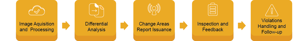
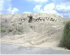
National land use monitoring project is to utilize remote sensing technologies to capture high resolution satellite images which were then analyzed to locate differences of ground feature on images obtained from different periods of time. Those changes might indicate suspect illegal uses, such as illegal constructions, sand and gravel mining, waste dumping, and other illegal developments. All relevant data are then uploaded to the online reporting system and reported to relevant local governments, and other agencies. These agencies will then dispatch inspectors to perform onsite inspections.
(1)Screening of Change Areas with Suspected Violations
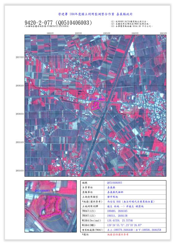
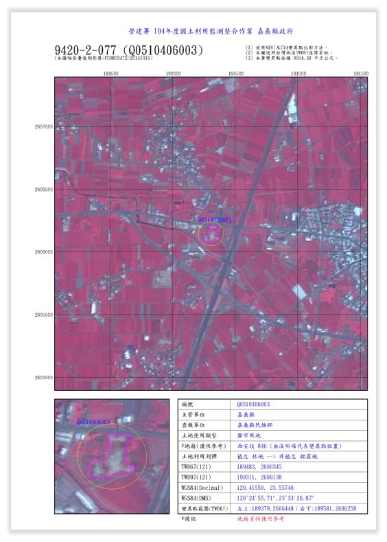
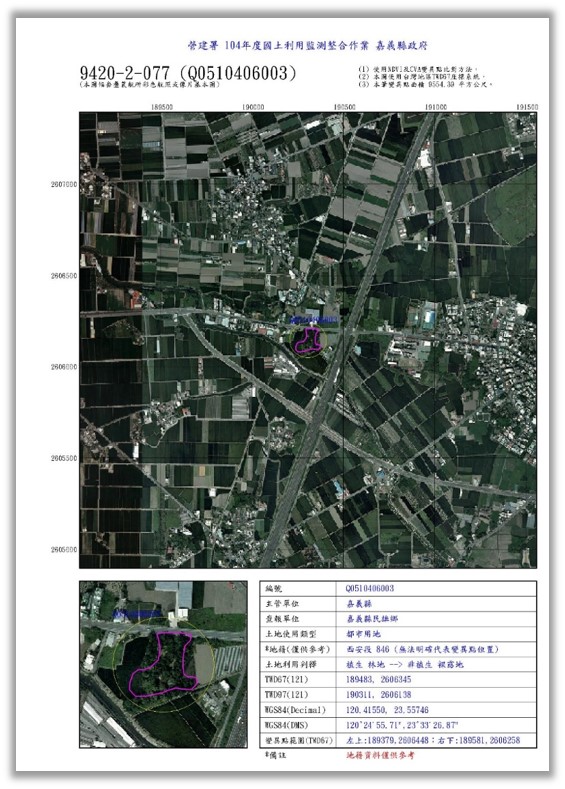
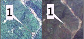
Most of the images used for land use monitoring are from Formosa Satellite #2 (FORMOSAT-2), with additional images provided by the SPOT system. After geometric corrections, computerized comparisons of previously captured images and currently captured images are then performed. Differences in textures, shapes, and spectrum are marked by the system, and a staff will manually match these differentials with color aerial photographs, photographic base maps, land use maps, electronic map, and slope shades to screen for change areas with suspected violations.
Regular Shape
Agricultural use is usually within a fixed scope with large scale changes
Regular Shape
Construction development is usually rectangular
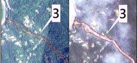
Irregular Shape
Illegal mining of sand and gravel is usually irregularly shape
Textured
Textured
Texture-less
..
(2)Summary of Notification and Report of Change Areas
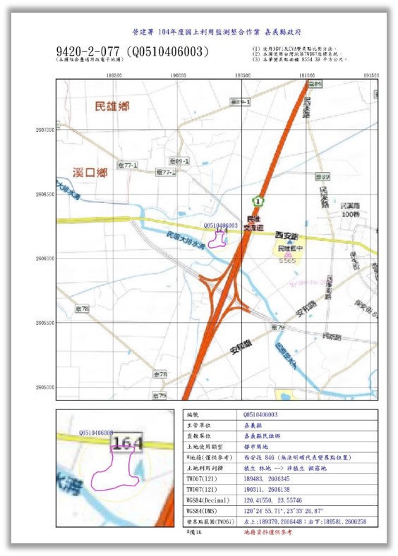
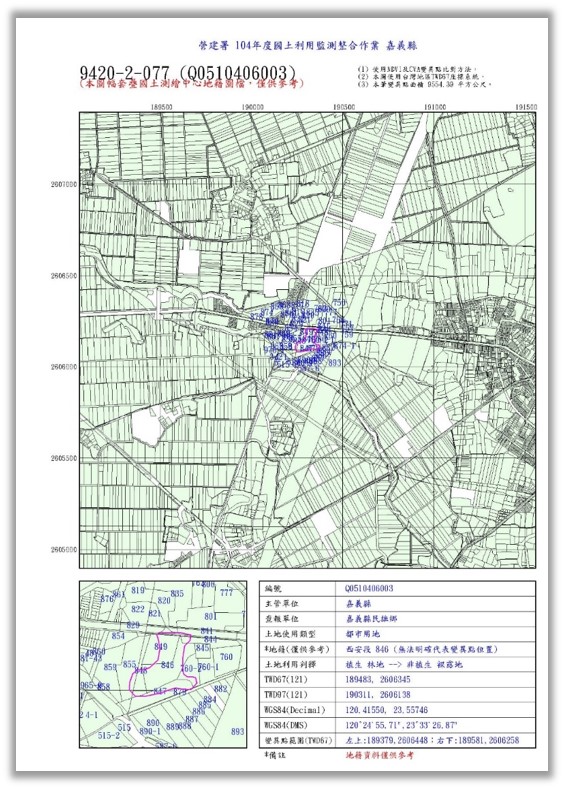
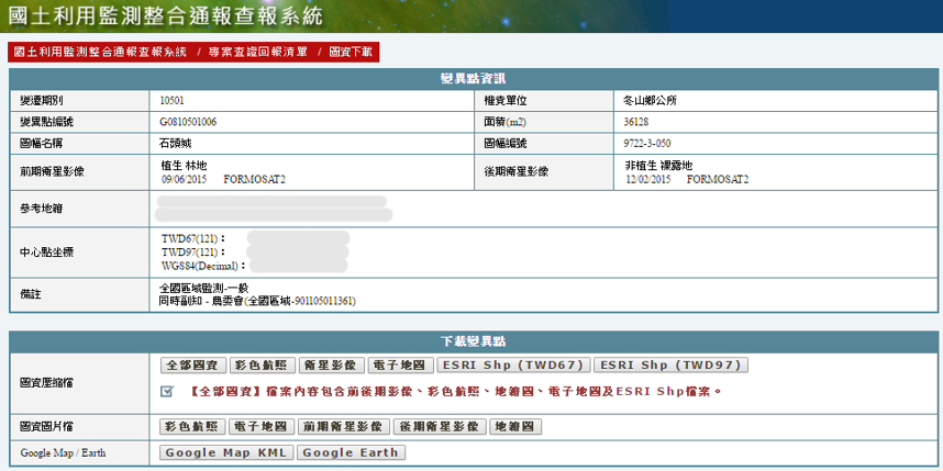
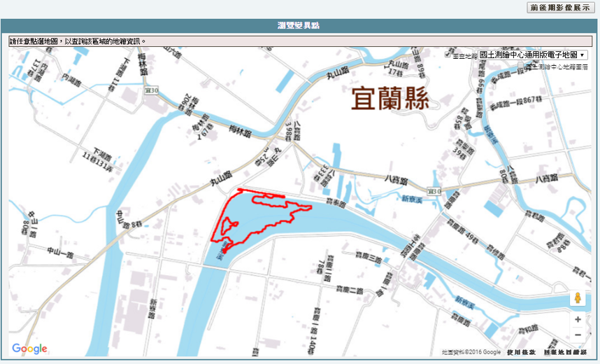
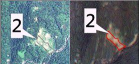
The change areas of suspected violations screened out via comparison, analysis, interpretation, and data archiving of change areas of satellite images of previous and later periods should be made into map data reports by using SHP file of scope of suspected change areas, satellite images of previous period, satellite images of later period, aerial photographs, electronic maps, and cadastral maps. These reports should be submitted to respective land supervision units, municipality and county (city) governments via online reporting to arrange onsite inspection, feedback result audit, and tracking of follow-up handling in order to surely keep track on land changes.
Sat. Imagery
(Prev. Period)
Sat. Imagery
(Curr. Period)
Aerial
Photography
Taiwan
e-Map
Cadastral
Map
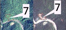
Hualien County
Previous Imagery
Current Imagery
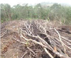
Violation Type: Deforestation
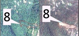
Kaohsiung City
Previous Imagery
Current Imagery
Violation Type: Illegal piling of sand and gravel
(3)Types of satellite image monitoring and their restrictions
Vegetation
↔
Built-Up Land
- New Building Addition
Vegetation
↔
Bare land
- Land Grading
- Soil, Stone Accumulation
- Natural Bare land
Vegetation
↔
Water Body
- Water Body Changed
Bare land
↔
Built-Up Land
- New Building Addition
Bare land
↔
Bare land
- Downward Excavation or Upward Stacking of Earthwork
Built-Up Land
↔
Built-Up Land
- Rooftop Add-On
..
Notification and Report Process
The agencies (including sponsor, co-sponsor, and execution agencies) involved in the integration of national land monitoring works include local and central agencies. In addition to the agencies for managing reporting operations, there are also central agencies or competent authorities regularly receive inquiries of information of change areas. In order to avoid any deficiency or doubt during operations of these coordinating agencies, the principles of notification are established as shown below:
- When Change Areas are located within the jurisdiction of coordinating agency of this monitoring integration project, the coordinating agency must be notified to management the monitoring operation, or the information of change areas can be obtained via system inquiry.
- When Change Areas are not located within the jurisdiction of coordinating agency of this monitoring integration project, the change areas monitoring operation should be managed by the local agency with the administrative jurisdiction of the location of change areas notification.
- When change areas are located within the jurisdictions or more than 2 central agencies, these central agencies should be notified to manage the monitoring operations of such change areas.
- When change areas are located within the jurisdiction of both local and central agencies, in principle the central agency should be notified to manage the monitoring operation of such change areas.
- When change areas are located within the jurisdiction of both local and central agencies (receiving change areas for business reference), in principle the local agency should be notified to manage the monitoring operation of such change areas.
The integrated system has started the online service on December 3, 2015. All agencies can receive information of change area and feedback inspection result via such integrated system while providing an effective platform for cross-agency change area transfer and information communication to reduce the time consumption by administration procedure and official document delivery; agencies newly included in the monitoring integration can also directly use the integrated system to execute inspection and reporting without the need for developing each individual reporting and inspection system. Each land management agency can also receive change area information via the integrated system for the need of business management.
| Land-Use Monitoring Report Process Flow |
|---|
|
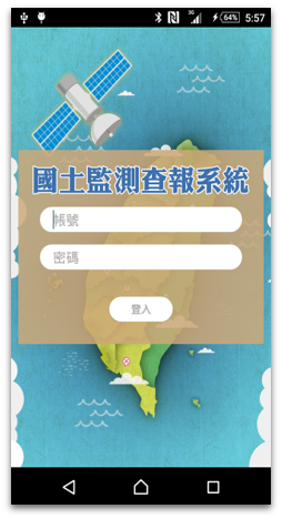
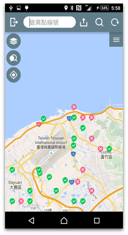
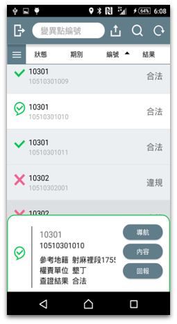
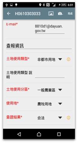
The overall integrated system aims at inputting results of land use monitoring systems in each period and the management of the follow-up operation procedure. A supporting function with the aid of applications for mobile devices in field investigations was added. A mechanism for a flexible system interface is also available. The reporting system also offers relevant statistics management and resulting analysis of the changes according to the requirements of individual units for the practical working situations. The system also provides open access for the public to browse dynamic databases of past satellite images and statistical results.
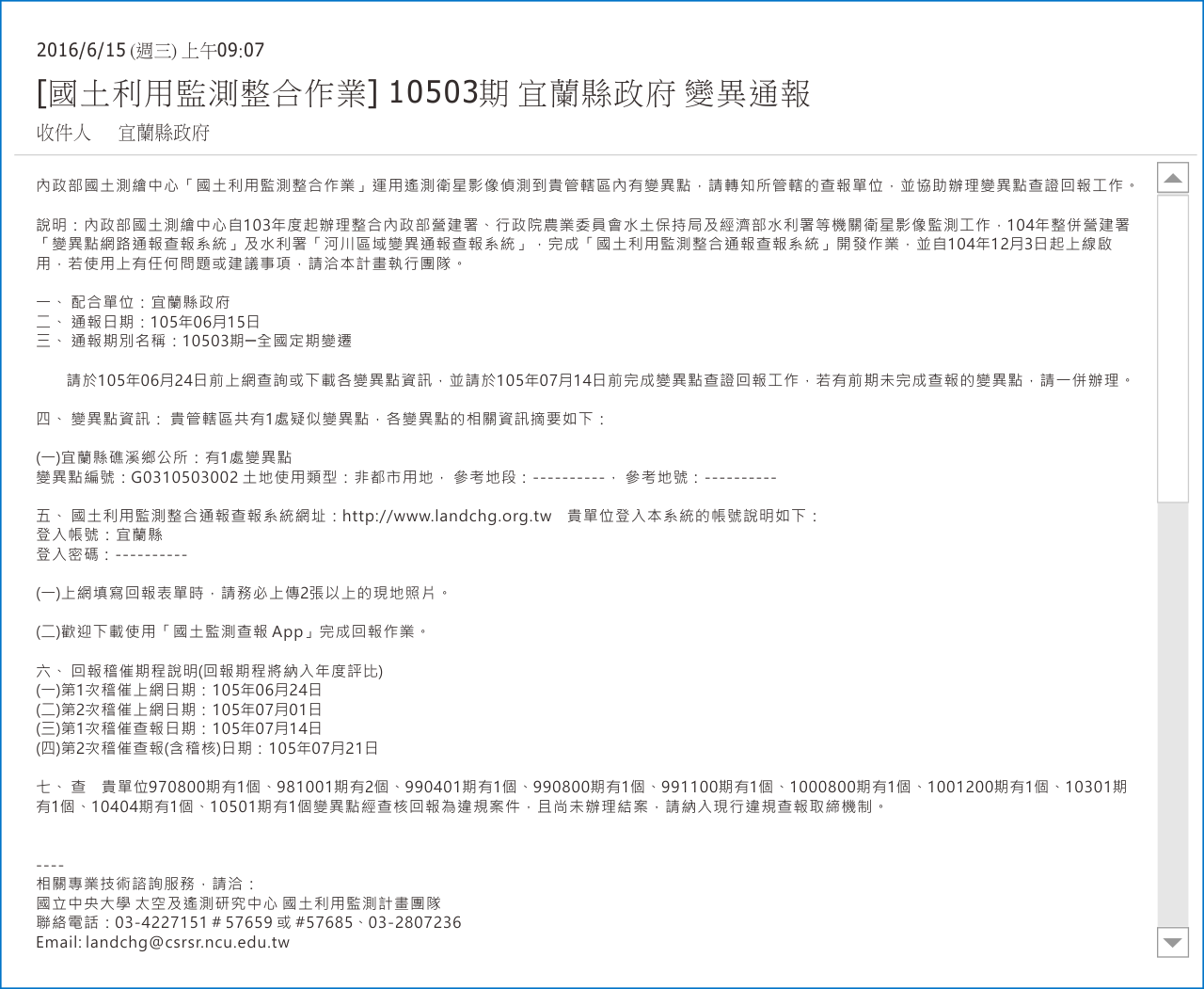
| Example of change notification email. |
|---|
|
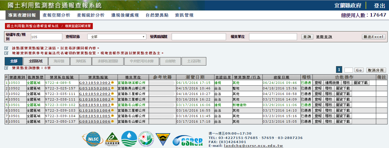
| The change area search and information download interface in the integrated system. |
|---|
|
Authorization
check
Change areas
platform
Check and review
change areas
Change ares
report

Off-line
operational
..
Participating Agencies
After the launching of integrated system on December 3, 2015, in addition to email notices send by the integrated system to all reporting windows, the reports of change areas will also be issued in accordance with division of business after coordination; CPAMI, SWCB, and WRA remain responsible for the audit, inspection, supervision or evaluation of change areas reporting and inspection carried out by each executing unit. The reporting coordination units of change areas and monitoring scopes after integration are as shown in the table below.
| Agency | Scope of Monitoring | |
|---|---|---|
| Local | Municipal and Country (City) Government | Urban Land: Agricultural areas and protected areas |
| Non-urban Land: Farming land, forest land, aquaculture land, water conservancy land, ecological conservation land, homeland security land, and business land with specific purpose | ||
| Slopeland: the slope land defined by Slopeland Conservation and Utilization Act | ||
| Central | National Park Group, CPAMI | Jurisdictions of Yangmingshan, Shei-Pa, Taroko, Yushan, Kenting, Kinmen, Taijiang, Marine National Park, Shoushan National Park |
| Land Division, CPAMI | Scope of land for public housing | |
| Comprehensive Plan Division, CPAMI | Scope of natural conservation area of shoreline protection project, scope of land (newly added scope of permitted county/city development) other than the building lands within the scope of base of approved non-urban land development case (Class A, B, C, D building lands and lands for specific target businesses) | |
| Council of Agriculture, Executive Yuan | General agricultural area, slopeland conservation area, forest area, specific agricultural area, urban planning agricultural area | |
| Forestry Bureau, Council of Agriculture, Executive Yuan | Jurisdiction of each forest management division | |
| Fisheries Agency, Council of Agriculture, Executive Yuan, Hydrology Division, WRA, MOEA | Areas with severe subsidence, such as newly added fish farms within the jurisdiction of Changhwa County, Yunlin County, Chiayi County, Tainan City, and Pingtung County | |
| NTU Experimental Forest | Jurisdiction of NTU Experimental Forest | |
| Central Office of MOEA | Scope of specific area designated in accordance Factory Management Counseling Act and Specific Area Designation Principle | |
| Taiwan International Ports Corporation, Ltd. | Jurisdiction of Port of Taichung, Taiwan International Ports Corporation, Ltd. Jurisdiction of Port of Kaohsiung, Taiwan International Ports Corporation, Ltd. |
|
| National Property Administration, Ministry of Finance | Scope of state-owned non-public land | |
| Taiwan Railways Administration, MOTC | Jurisdiction of Taiwan Railways Administration, MOTC | |
| Veterans Affairs Council | Wuling Farm, Taitung Farm, Fushoushan Farm, Cingjing Farm, Changhwa Farm, and jurisdiction of Veterans Affairs Council | |
| Bureau of Mines, MOEA | Specific scope of monitoring of quarrying | |
| First River Management Office | Lanyang River, Heping River | |
| Second River Management Office | Fengshan River, Touqian River, Zhonggang River, Houlong River | |
| Third River Management Office | Da-an River, Dajia River, Wu River | |
| Fourth River Management Office | Jhuoshuei River | |
| Fifth River Management Office | Beigang River, Putzu River, Bazhang River, Jishui River | |
| Sixth River Management Office | Zengwun River, Yanshui River, Erren River, Agongdian River | |
| Seventh River Management Office | Gaoping River, Donggang River, Sihchong River | |
| Eighth River Management Office | Beinan River | |
| Ninth River Management Office | Hualien River, Xiuguluan River | |
| Tenth River Management Office (including New Taipei City, Keelung City, Taoyuan City) | Tamsui River, Huang River | |
| Northern Region Water Resources Office | Shihmen Reservoir, Ronghwa Dam | |
| Central Region Water Resources Office | Liyutan Reservoir, Shihkang Dam, Jiji Weir | |
| Southern Region Water Resources Office | Jiasian Weir, Mudan Reservoir, Agongdian Reservoir, Gaoping Weir, Zengwun Reservoir | |
| Taipei Water Management Office | Taiwan Water Source Specific Area | |
..
Achievements of Value-added Applications
(1)Analysis of Utilization and Development of Existing Lands in Industrial Zones and Parks
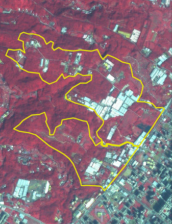
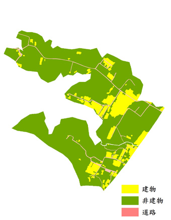
Industrial zones and parks (such as Science Park, Biotechnology Park, etc.) play an important role in the history of industrial development in Taiwan. In recent years industries in Taiwan have been under the impact of globalization and post-industrialization changes, such that the supply and demand of industrial lands have also been changed. To fully understand the current status of land use within industrial zones and parks in Taiwan, the latest satellite images were divided into three categories of roads, buildings, and non-buildings based on object classification method and national land use investigation data to interpret building distributions in industrial zones and parks. Statistical analysis of the development rate was also conducted to elucidate the current status of physical development or non-development within these zones and parks.
| An example of value-added application : Linkou Industrial Park Zone 1 | |
|---|---|
| Administrative District | Type |
| New Taipei City, Linkou District, Wugu District, Taishan District | County (city) Registered Industrial Zone |
 |
 |
SPOT-6 : Mar 3, 2016  |
|
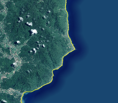
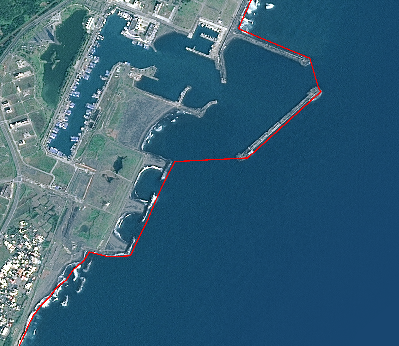
(2)Shoreline Changes Detection Operation
To implement the policy goal of “No more reduction of the ratio of natural shore”, a policy of the National Sustainable Development Commission, Executive Yuan, the Annual Tide Tables of Central Weather Bureau, Ministry of Transportation and Communications were used as a reference in conjunction with the water level data measured by all tidal stations. In addition, high resolution satellite images after fusion at a relatively high tidal level each day were collected and summarized to conduct shoreline change detection and digitalization operations. The changes to natural shoreline and artificial shoreline were calculated and summarized accordingly thereafter. The overlapped images of natural shoreline and artificial shoreline example are as shown below.
| Natural Shoreline | Artificial Shoreline |
|---|---|
 |
 |
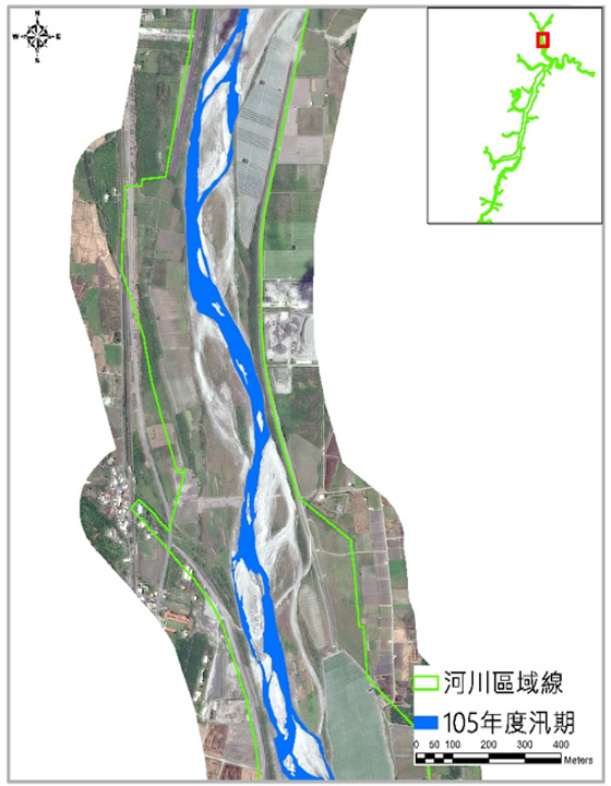
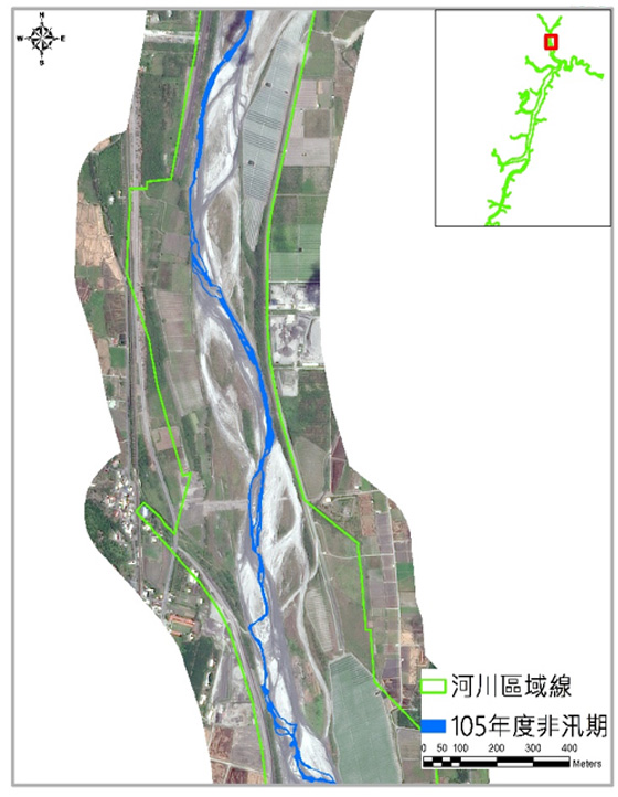
(3)River Deep Groove Digitalization and Exposed Land Interpretation Operations
With global climate change trends in recent years, the changes in intensity, time sequence, and distribution of rainfalls and the river flow would lead to prolonged dry seasons or abruptly increased river channel. Long non-flood seasons, fallow periods, and cultivation practices by farmers have led to depleted water sources and plantation coverage, thus exposing land with a high probability of erosion and dust emissions. The resulting establishment of river channel and bare land are used as a reference for river governance, farm planning, and dike renovation. The deep groove results in flood season and non-flood season are as shown below.
| Deep groove achievement of Xiu-Gu-Luan Creek in 2016 | |
|---|---|
| Flood Season | Non-Flood Season |
 |
 |
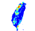
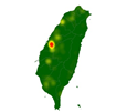
(4)Spatial Analysis Result of Change Areas with Suspected Violations
CPAMI, SWCB, and WRA have accumulated considerable monitoring results in periods during the execution of past land use monitoring. To expand the application of these results, the distributions of change areas with violations based on reports over the years were summarized via spatial visualization or statistical charts. This summary can be provided to various agencies as a reference for rolling adjustment of the national land use monitoring execution plan and administration measures (such as national land planning, report punishment, and local advocacy). The examples of hot spots distributions of change areas with violations are as shown below.
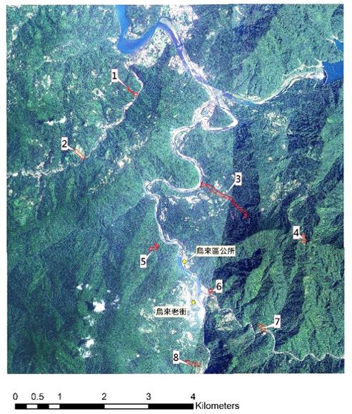
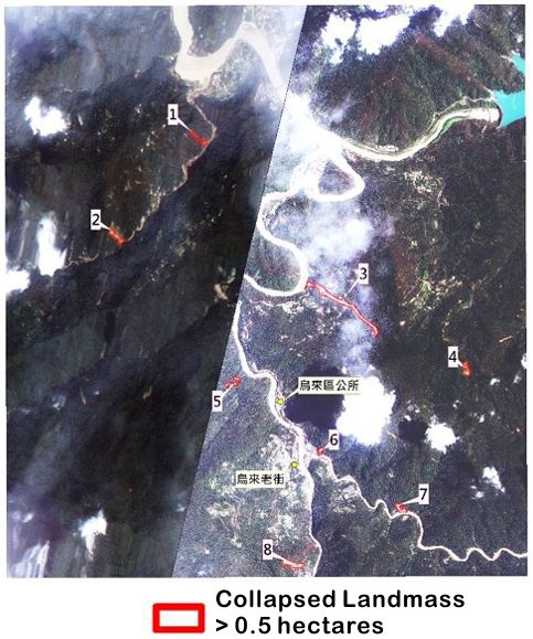
(5)Result of Emergency Disaster Response
In the events of emergency disaster, such as the interpretation of a collapsed barrier lake or a river management emergency, the emergency disaster response and relevant business requirements should be submitted in coordination with relevant authorities to arrange value-added applications based on satellite images. For example, after Typhoon Soudelor, Typhoon Dujuan, and the Tainan Earthquake,it has provided assistance in satellite image comparison and interpretation of land collapse results before and after the disaster, which can serve as a reference for relevant authorities. The results of emergency response are as shown in the figure below.
| Disaster Analysis after Typhoon Soudelor — Nanshi River Region (Near Feitsui Reservoir) |
|
|---|---|
| Pre-Disaster Imagery (2015/3/14 - 5/30) | Post-Disaster Imagery (2015/8/11) |
 |
 |
|
|
..
Project performance and future outlook
(1)Effectiveness of Plan Promotion
Acting on the instruction of integrating existing governmental monitoring plans by MOI, the NLSC began the integration plan in 2014. Based on the original monitoring resources, the monitoring frequency of each agency was adjusted to once every 2 months, and the satellite images with the ground resolution from 1.5 m to 2.5 m were chosen to be used. The national land use monitoring and reporting operation has been launched over the entire country (the island of Taiwan, Penghu County, Kinmen County, Lianjiang County, Lanyu, Green Island, and Liuqiu). The monitoring frequency of certain areas was increased to meet the special requirement of WRA. A comparison between the monitoring operations before and after the integration is as shown in the figure below.
| Managing Agency | Purpose | Image Resolution (m) | Scope of Monitoring | Monitoring Frequency | |
|---|---|---|---|---|---|
| Before consolidation | CPAMI | Assisting in non-urban and urban land management | 2 – 2.5 | The island of Taiwan, Penghu County, Lanyu, Green Island, Liuqiu, Kinmen County, Liangjiang County of Fujian Province | Monthly |
| Shoreline and sea area monitoring and management | Half-yearly | ||||
| WRA | Illegal violations in river area | 2 – 2.5 | The scope of rivers and reservoirs administered by central government | Monthly or Biweekly | |
| SWCB | Overuse of slopeland | 8 – 10 | Slopeland | Bimonthly | |
| After consolidation | NLSC | Integration of satellite monitoring works of 3 aforementioned authorities since 2014 | 1.5 – 2.5 | The island of Taiwan, Penghu County, Lanyu, Green Island, Liuqiu, Kinmen County, Liangjiang County of Fujian Province | Bimonthly High frequency for WRA: Monthly or biweekly |
Since 2014, monitoring ranges required by Taiwan Railway Administration, Bureau of Mines, Veterans Affairs Council and its affiliated Wuling Farm, Taitung Farm, Fushoushan Farm, Cingjing Farm, and Changhwa Farm also have been included in addition to the original monitoring ranges of CPAMI, SWCB, and WRA. The onsite reporting violation rate before and after the integration of monitoring within the scope of national land monitored was reported 15.4% in 2013, 18.5% in 2014, 18.2% in 2015 and 19.9% in 2016 and 22.3% in 2017. The growing reporting violation rate have indicated that the increased monitoring frequency and enhanced monitoring image quality did lead to a raising number of violations found after the integration.
(2)Design of Future Goal
- Periodic engagement in national land resources survey and land use monitoring, and providing basic map data for national land planning, land management, monitoring mechanism, ecology conservation, environmental protection, and forest land maintenance in accordance with Article 19 of National Land Planning Act.
- Effective integration of monitoring resources of various agencies in order to reduce repeated investment of government resources and enhance the effectiveness, magnify common administrative functionality of agencies, quickly collect current status and variation information of use of land resources, and effectively prevent unlawful land use.
- Establishment of Land Use Monitoring and Notification Integrated System based on complete and timely communication in order to facilitate the online reporting operations by various agencies.
- Management of value-added applications of satellite images and the image capture, processing, and analysis for emergency response in order to meet the requirements of national land management of various agencies.
- Maintenance of temporal monitoring database and utilization of big data analysis function in order to provide potential decision making information of temporal monitoring data over the years as the reference for decision making by various competent authorities.
- Promotion of joint participation in national land use monitoring activities by volunteers and private organizations in order to reduce the land use violations and achieve the objective of sustainable development of national land.
..